Robertson's Windmill Historical Report, Block 28 Building 24A Originally entitled: "Report on the Location of Robertson's Windmill"
Colonial Williamsburg Foundation Library
Research Report Series - 1546
Colonial Williamsburg Foundation
Library
Williamsburg, Virginia
1990
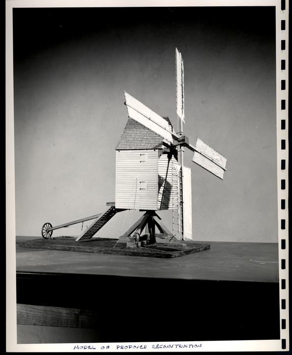 MODEL
OF PROPOSED RECONTRUCTION
MODEL
OF PROPOSED RECONTRUCTION
 OLD
MILLS, COAST OF VA. J.D. SMILLIE 1890 N.Y. PUB. LIB.
OLD
MILLS, COAST OF VA. J.D. SMILLIE 1890 N.Y. PUB. LIB.
REPORT ON
THE
LOCATION OF ROBERTSON'S WINDMILLBased Upon Documentary and
Archaeological Evidence
LOCATION OF ROBERTSON'S WINDMILL
ESTABLISHMENT OF THE AREA WITHIN WILLIAMSBURG
An indenture made December 12, 1723 between William Robertson and John Holloway reads in part as follows:
"...sell...unto the said John Holloway and his heirs all those four lots of Ground lying & being in ye City of Wmsburgh denoted in ye plan of the said City by the figures 236, 237, 207, 208 being the lots whereon ye said William Robertson's Windmill stands together with the said Windmill and all Houses, buildings, Yards, Orchards, ways Waters profits Easements & Commodities to the said four lots and other the premises belonging..."Since these four lots are identified by one improvement, the windmill, they must have comprised a single contiguous parcel.
William Robertson had purchased the above four lots and four others from the Trustees of Williamsburg on November 15, 1714. These lots are designated in his deed as follows:
"...Eight certain Lotts of Ground in ye sd City of Wmsburgh designed in ye Platt of ye sd City by these figures 232, 233, 234, 235, 236 237, 207 & 208 with all Woods thereon growing..."This deed was subject to re-possession unless each lot was built upon within twenty-four months in accordance with the Act of the Assembly dated October 23, 1705.
The eight Robertson lots moat have been in a single
contiguous tract because the eight lot numbers are all in sequence except two,
(207 and 208) and these two are a part of the four lots which composed the
Robertson's Windmill tract
Fig. I
PHOTOSTAT COPY OF THE WILLIAMSBURG, THE OLD COLONIAL
CAPITOL" BY LYON G. TYLER
Note: This map is a combination of the College Map (circa 1791) and the
Bucktrout Map (1807) with certain additions by the author.
2
(236, 237, 207, 208) which was a contiguous group as shown above.
Robertson sold Lots 233 and 231, to Ludwell on Dec. 19, 1715 and the deed description places them on the north side of the Market Square, as follows:
"...Two Lotts of Ground in ye City of Wmsburgh lying on ye North Side of ye Market Place, & denoted in ye Plan of ye sd City by these figures (233 & 234) With all & singular ye Houses, Yards, Gardens..."
Since the Robertson tract of eight lots was a contiguous tract and the dead to Ludwell locates two lots of the group on the Market Square the entire block of eight lots must also have been located there.
The Tyler map (see fig. I) shows two blocks of contiguous lots on the north side of Market Square. The block west of North England Street could not well have been Robertson's lots because they bear other numbers. The lots east of North England which are bounded
On the south by the Market Square, (Nicholson St.)as indicated on fig. I, bear no numbers and maps therefore have been the Robertson tract.
On the west by North England Street,
On the north by Scotland Streets
On the east by Queen Street extended,
Furthermore this is
the only group of eight lots shown unnumbered on the existing old maps of
Williamsburg (the College map of circa 1791 and the Bucktrout map of 1807) in a
location answering the description given in the deed (1715)
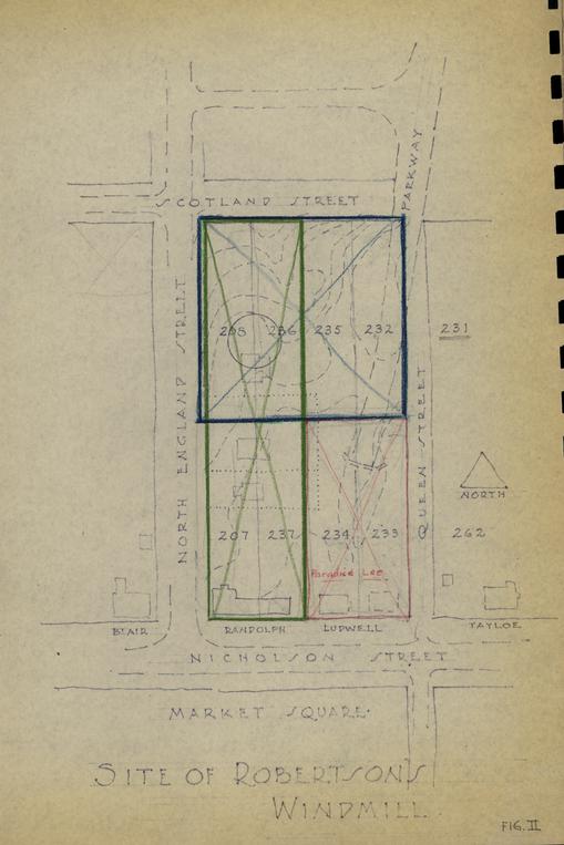 Fig. II
SITE OF ROBERSON'S WINDMILL
3
Robertson to Ludwell ("lying on the north side of the Market Place").
ESTABLISHMENT OF THE LOCATION OF THE SITE WITHIN THE TRACT
The Ludwell lots (233 and 234) subsequently came into the ownership of Paradise and Lee and two lots west of Queen Street on Nicholson Street are designated by these names on 18th century maps.
The four Hollowly lots (236, 237, 207 and 208) must therefore have been either the four along North England Street (marked in green on fig. II) or those along Scotland Street (marked in blue on fig. II), since we know that lots 233 and 234 occupied the corner of Nicholson and Queen Street extended and we have shown from their description (p. 1) that the Holloway lots formed a single block.
However, on July 20, 1724, eight months after his purchase from Robertson, John Holloway sold a lot to John Randolph described as follows:
"...All that Messuage and Lot or half Acre of Lands Situate and lying and being in the City of Wmsburgh adjoining to the Lot whereon the said John Randolph now lives which he the said John Holloway lately purchased of William Robertson..."Since the records in 1770 and 1773 describe the Paradise/Lee lots (234 and 233) as "adjoining the Speaker", and "next door but one to Mr. Speaker's", (at this date Peyton Randolph was the speaker of the House of Burgesses) the lot Randolph purchased and the one on which he was then living may have been either on the corner of Nicholson Street and North England Streets, or north of the Ludwell lots at the corner of Queen Street extended and Scotland Street extended.
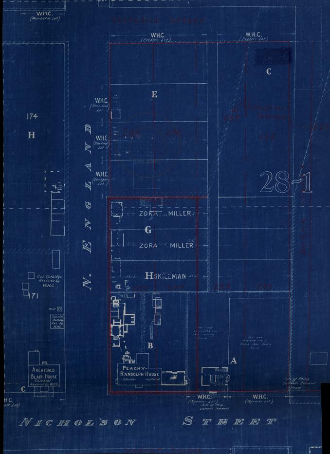 Fig. III
ARCHAEOLOGICAL EXCAVATION
The Randolph house must, however, have been on the corner of Nicholson and North England Streets because it remained in the family and upon the death of Mrs. Betty Randolph (1783) who inherited from Peyton Randolph it was offered for sale and described as follows:
"...two stories high, with four rooms on a floor, pleasantly situated on the great square..."
And, since the Randolph lot was one of the contiguous Holloway lots these (236, 237, 207 and 208) must have been the lots along North England Street (see figure II) rather than those along Scotland Street.
ESTABLISHMENT OF ACTUAL WINDMILL SITE
We know the windmill to have been on the block of four lots sold by Robertson to Hollowly (see p. 1). Since the Randolph family occupied the south end of the block of lots, the windmill must have been located on the remaining two lots, i.e., the ones at the corner of North England and Scotland, which on Fig. II bear the numbers 208 and 236.
If the objection be raised that the windmill might have existed on the two lots at the corner of North England and Nicholson Streets prior to Randolph's occupancy of these lots, it may be pointed out that the windmill existed in December, 1723 when Robertson sold the four lots to Holloway (see p. 1) and that eight months later, July, 1724, when Holloway sold one of the lots to John Randolph, the latter was already living on the tract under discussion (see p. 3). It is not likely, either that Randolph, in this eight-month interval, had been able to move the windmill and erect himself a dwelling or that, assuming that he was living on 5 one of the two lots at the corner of North England and Nicholson Streets when Robertson sold the lots to Holloway, he would have elected to move onto a lot having a windmill on it. In addition, it is unlikely altogether that a windmill would have been erected on a lot so desirable for living uses as one of those fronting on the Market Square.
Furthermore, since the presence of a windmill was used to identify the four lots when Holloway purchased them, it appears reasonable to suppose that it would have been used again, eight months later, if the windmill had been on the lot.
An architectural examination of the existing building, called the Peyton Randolph House, reveals construction and details compatible with those of the first quarter of the 18th century.
Archaeological investigation of the two colonial lots facing Nicholson Street, now occupied by the Peyton Randolph House, and the two colonial lots to the north on North England Street facing Scotland Street which may have some into possession of the Randolphs, giving them the original Holloway tract, reveals a complex of 18th and 19th century outbuildings running all the way to the north line of the lots facing Nicholson Street (figure III) and stopping there. As shown in the Report on Outbuildings of the Peyton Randolph House a use for most of these foundations may be deduced. Only one 18th century foundation was found on the two lots at the corner of North England and Scotland Streets. (See Figure III and bldg.(15) Figure V).
None of the remains can be in any way related to windmill construction but they do comprise a reasonable group of outbuildings for the Peyton Randolph 6 house which is compatible with documentary references. (See figures IV & V)
To recapitulate:
- (1)The Ludwell lots, numbered 233 and 234, and the Randolph lots were undoubtedly along Nicholson Street.
- (2)The Randolph lots were part of the tract sold to Holloway with the windmill.
- (3)Because of the location of the Ludwell lots and their relation to and the location of Randolph's, the Holloway tract must have laid along North England.
- (4)Because of the houses which existed on the Nicholson Street front of the Randolph property the windmill must have been on the northern two lots.
STATEMENT.
The entire area of the eight lots originally (1714) owned by Robertson except that now covered by buildings has been investigated by Colonial Williamsburg by means of archaeological cross trenching. No evidence of a windmill could be identified.
The evidence presented in this analysis, has convinced us, in the absence of conflicting documents, that the windmill stood on the high ground just south of the middle of the acre formed by the two colonial lots on the corner of North England and Scotland Streets.
ESTABLISHMENT OF SEQUENCE OF LOT NUMBERING
The eight lots deeded in 1714 to William Robertson by the Trustees were described as numbers 232, 233, 234, 235, 236, 237, 207 and 208, but no existing 7 plat of Williamsburg bears these numbers. As shown above, the eight lots were in the block bounded by Nicholson, North England, Scotland and Queen Streets.
Only two (233 end 234) of the original eight lots are located by deed description (1715) and they are placed on the north side of the Market Place. The College map (1791), Lyon G. Tyler's map (Fig. I) and the Bucktrout map (1807) show the names of Lee and Paradise on the two lots on Nicholson Street at the corner of Queen Street (see fig. I).
Four more lots (236, 237, 207 and 208) shown above to be a contiguous parcel are described in the deed (1723) of transfer to Holloway by number only with no location given. One of these was apparently sold by Holloway to Randolph the next year because in the deed it is identified as one "recently purchased" of William Robertson. The Randolph lot has been shown above to be located on Nicholson Street at the corner of North England.
The College map and the Bucktrout map indicate a lot numbered 231 at the South-East corner of Scotland and Queen Streets (projected).
To summarize, this much is known:
- 1.Lots 233 and 2314 were contiguous and faced Nicholson Street west of Queen.
- 2.Lots 236, 237, 207 and 208 were contiguous and lay along North England, two facing Nicholson and two facing Scotland.
- 3.The remaining two lots, 232 and 235 must therefore have been to the north of lots 233 and 234 and facing on Scotland Street.
- 4.The location of lot 231 in the next block to the east suggests that of the two lots, 232 and 235, the one nearest lot 231 would have been 232.
From the above it may be seen that the eight lots purchased by William Robertson in 1714 may have been located as indicated by the numbers shown on figure II.
Fig. IV
PLAN OF FOUNDATIONS UNCOVERED AT PEYTON RANDOLPH HOUSE - SCALE 1/16" =1'0"
COLONIAL WILLIAMSBURG ARCHITECT'S OFFICE, FEBRUARY 2, 1956. [oversized image]
Fig. V
RECONSTRUCTION PLAN PEYTON RANDOLPH OUTBUILDINGS SCALE 1/16" = 1'0"
COLONIAL WILLIAMSBURG ARCHITECT'S OFFICE. FEBRUARY 2, 1956. [oversized image]